
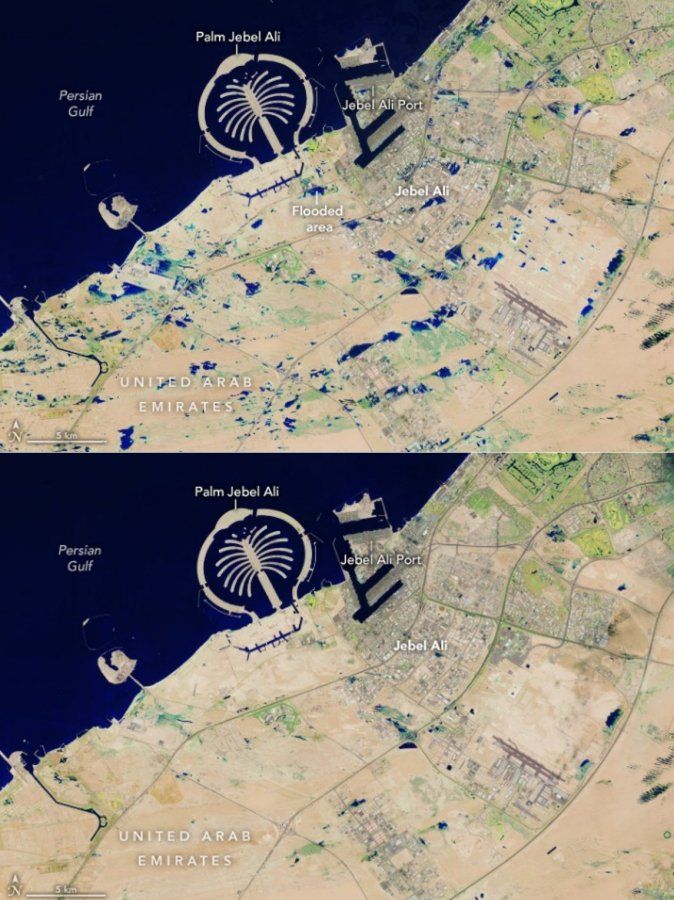
Last week, Dubai was hit by record intense rainfall. In 24 hours, 164 millimeters of water fell, which is the most in the history of the measurement there (but which lasts only about 70 years). They even measured 254 mm on the border with Oman! In any case, considering the desert region, it was extremely heavy rain that led to extensive flooding. Their consequences, including a significant disruption to the operation of the huge Dubai airport, were a media-gracious topic. And especially on social networks, in addition to the own videos of the large water, a rich discussion about the causes of this exceptional event started, including certain even conspiracy theories, which mentioned deliberate artificial interventions in the clouds carried out in order to cause rain. To some extent, this may be related to the fact that the United Arab Emirates has been running experiments for many years aimed at increasing rainfall in this desert country. At the same time, it is mainly concentrated in the mountainous areas near the border with Oman, where there are many water reservoirs.
Satellite view of parts of Oman before and after heavy rains, source: copernicus.eu
Satellite view of Dubai under and before heavy rains, source: copernicus.eu
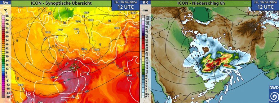
From a meteorological point of view, last week’s heavy rainfall was caused by a high-altitude trough of low air pressure over Western Asia, which extended unusually southward. As a result of dynamic causes, a pressure trough was subsequently formed in the ground levels of the atmosphere. At the same time, the pressure lows support the outgoing movements, thanks to which the moisture of the air masses from the Persian and Gulf of Oman regions could be transported to a height where condensation of water vapor took place, the formation of clouds and precipitation. It is worth emphasizing here that even though this part of the world is a desert, the air contains a relatively high amount of water vapor coming from the surrounding sea areas. Due to the practically permanent effect of pressure heights, which block the emergence of more significant outputs, but it has no chance to get high enough to condense.
Left: pressure field near the ground (white lines) and 500 hPa height (black), color-equivalent potential temperature – the higher the values, the warmer and wetter the air is. Right: 6-hour total precipitation forecast (noon UT on April 16), source: dwd.de
From a meteorological point of view, the low pressure “sucked” into itself extremely humid and hot air, which helped the unusually stormy development of clouds and precipitation (the so-called train effect was partly added, when the given region was repeatedly hit by storms). And the relatively slow progression below further aided the aforementioned extreme rainfall totals. They also hit Oman before Dubai, where floods claimed at least 18 lives. Of course, the local infrastructure, which – for relatively logical reasons – is not designed for such a thing, also contributed to the effects of the devastating floods. Sewage does not exist, with exceptions, and the water then remains stagnant on the streets and roads and drains away only very slowly.
Right after the extreme downpours, a whole series of speculations regarding the above-mentioned “cloud-seeding”, i.e. artificial interventions in the clouds leading to artificial rain, sprang up. According to the meteorological office of the United Arab Emirates, however, no such intervention took place at the time (reuters.com). From a meteorological point of view, in this case, the consideration of artificial interventions also makes no sense. As it follows from experience and modeling, the effects of artificial cloud infection only lead to precipitation of lower intensity. The primary goal is to inject suitable particles into the clouds, which serve as condensation nuclei and support the formation of droplets, which subsequently, under suitable conditions, lead to rain that would otherwise not fall. However, in the case of the heavy rain that hit Dubai last week, the intervention would have practically no significant effect. During the development of such abundant precipitation, the number of condensation nuclei before the event itself had to be sufficiently high. Any additional material would have virtually no effect. At the same time, the question arises, why “infect” the clouds when we know that they will bring enough precipitation. The forecast models had been expecting heavy rainfall for several days in advance, in the amount that actually fell in the end. At the same time, the “cloud seeding” effect does not play any role in the numerical models, because it is not included in them at all.
But what could have played a certain role is another artificial human intervention, in the form of climate change. The seas around the Arabian Peninsula are above average warm, which facilitates evaporation. Warmer air will hold more water vapor, which can then, under the right conditions, condense and lead to more extreme precipitation than before. But this also applies to other parts of the world, not just the Middle East.
Tags: Record rainfall hit Dubai week artificial interventions weather
-


